IELTS Task 1 – Academic – Island for Tourists
IELTS Writing Task 1 – Academic – Island for Tourists
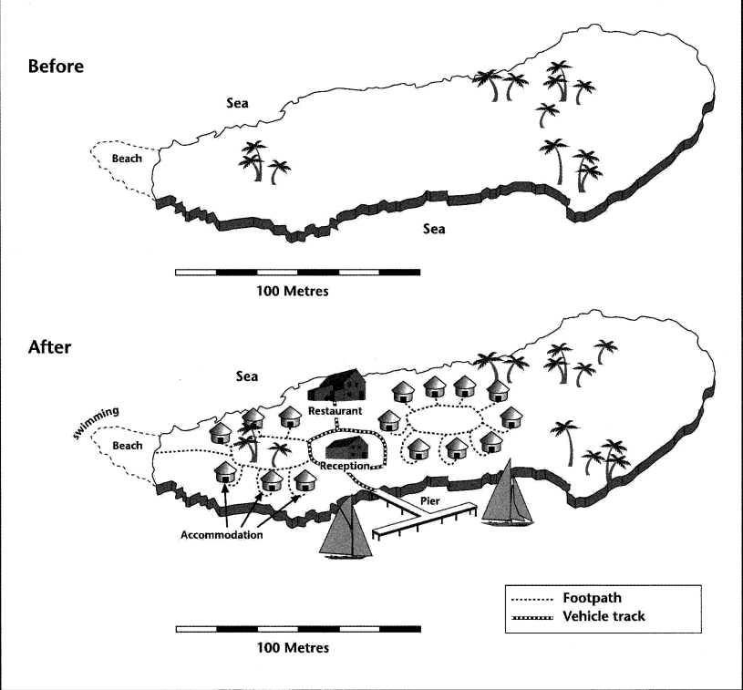
The two maps below show an island, before and after the construction of some tourist facilities. Summarize the information by selecting and reporting the main features, and make comparisons where relevant.
Impression
- There is a 100-meter length description so we can use this one.
- The Eastern side of the map is untouched.
- Pier is most likely the entrance to the island.
Introduction – Three Versions
- The maps compare the before and after images of an island construction for tourists. Overall, the western side was heavily constructed while there are minimal changes on the eastern part.
- The two maps compare the island before and after its construction of facilities for tourism. Overall, a series of accommodations were built around the western side of the island.
- The first map shows an island before any construction was made while the second map describes the changes that were made for tourists. Overall, the 250-meter island became commercialized by adding amenities such as accommodations and a restaurant.
Version 1
The maps compare the before and after images of an island construction for tourists. Overall, the western side was heavily constructed while there are minimal changes on the eastern part.
Before, the 250-meter-long island had no man-made building construction. On the west corner there is a beach and going to the eastern side there are a few trees that can be spotted. The eastern part has more land masses than the western part.
After the construction, the beach became a place for tourists to swim, and there is a footpath available for people to walk to their respective nipa-huts. These six available accommodations are built around trees and going further into the middle of the island, the reception office is erected. On the northern side of the office, there is a restaurant and a pier on the south, both of these are connected by a vehicle track. Further east, another nine nipa-hut style housings can be found, however, it is not connected to the main vehicle track, unlike the eastern counterpart. With the exception of some trees, the farther eastern section of the island remained unchanged.
Version 2
The first map shows an island before any construction was made while the second map describes the changes that were made for tourists. Overall, the 250-meter island became commercialized by adding amenities such as accommodations and a restaurant.
The island before had no man-made facilities but after the construction, there is now a pier located in the southern part of the island, where sails can be tethered. There is an available track for vehicles going to the reception office, located in the center of the island, and a restaurant in the northern section.
In between the reception, there are two nipa-hut-style accommodations, six housings in the west connected via footpath around the trees, and the footpath is direct to the beach for tourists to swim. On the eastern side, nine rooms are available but it is not directly connected to the vehicle path. Although the far eastern part of the island has more land mass, it was left unchanged.
IELTS Writing Version 3: Before and After (Island)
The first map depicts the island without any man-made structures, while the second map displays the constructed island with various facilities for tourism. Despite the eastern part having the largest landmass, the concentration of tourist facilities is focused on the west.
Before the construction, the 250-meter island was an empty space covered by the sea. Most of the trees were located in the eastern part, and there was a beach area in the west. Furthermore, the central part of the island was vacant.
Following the construction, the beach on the western side has been converted into a swimming facility for visitors, complete with a footpath leading to six nipa hut-style accommodations. In the center of the island, there is a reception area that is accessible from both the footpath and a vehicle path. Within the reception area, the northern part houses the restaurant, while the southern part features a T-shaped pier for various activities. On the eastern side of the island, there are an additional nine nipa huts, but these are not connected to either the footpath or the vehicle path.
IELTS Writing Version 4: Western and Eastern (Island)
The two maps of the same island compare the before and after the construction, aimed at catering to tourists. Overall, the western and central parts of the island were significantly commercialized, while the eastern part remained untouched.
While the island lacked man-made facilities before the construction, it underwent a transformation to accommodate tourists after the development. The entrance to the island commences from the southern-central portion, featuring a T-shaped pier where sailboats can anchor, leading to the island’s center where the reception stands. Traveling north from there, a restaurant, with accessibility for cars along this route.
Positioned on the western side of the reception, six accommodations were designed in a nipa hut style, all interconnected through a footpath. Further west, a beach awaits tourists for swimming. Conversely, on the eastern side, there are nine nipa hut-style accommodations, which, notably, remain disconnected from the pathway leading to the reception. Meanwhile, the far eastern section of the island retains its natural, untouched state.
Personal Notes
I recently updated this part as I’ve learned many new techniques for crafting a well-structured answer. My intention is for readers to comprehend that writing enhances your capacity to identify flawed or improved writing in the future. I didn’t specifically concentrate on expanding my vocabulary; rather, I prioritized delivering answers as effectively as possible. You may notice that I didn’t utilize an excessive number of words, yet it’s evident that it’s feasible to compose a response with a concise 150+ words while maintaining clarity and coherence.
My Rules
Here are my personal rules when it comes to writing test 1. I wouldn’t claim that I meet all these criteria perfectly. However they serve as a guideline for me to ensure I produce a satisfactory response:
Task 1:
1. Aim to write approximately 160 to 190 words.
2. Your essay should consist of 6 to 8 sentences in total.
3. Structure your essay into three paragraphs:
a. Paragraph 01: 35 to 40 words
i. One sentence for the introduction.
ii. One sentence for the overview.
b. Paragraph 02:
i. Two to three sentences only (ranging from simple to complex).
c. Paragraph 03:
i. Two to three sentences only (ranging from simple to complex).
4. Do not include a conclusion.
5. Use only “Overall” or “In general” in your overview.
6. Avoid using words you are not familiar with.
7. Provide facts only; do not include any personal opinions.
8. Imagine that the examiner cannot see the image; provide a clear description, avoiding vague expressions.
9. If you need to replace a word, ensure it is at the same complexity level or higher.
10. Avoid adding unnecessary words to lengthen your essay. If the examiner can remove a word, and the idea remains unchanged, it is unnecessary.
Check my other IELTS Writing.
Check my website.

Ian Tanpiuco is an ESL and virtual assistant. With a decade of experience, he has become an expert in his field. Dedicated to helping others achieve their goals, Ian works tirelessly in the classroom or as a virtual assistant.